A Visitor's Glossary of Cornwall: Local Terms Worth Knowing
Cornwall has its own vocabulary, drawn from the Cornish language, the local geography, the mining and maritime heritage, and the safety messaging that goes with a long Atlantic coast. This is a short visitor's glossary of the terms that come up most often when reading about Cornwall, planning a visit, or finding your way around once you're here.
Each entry is a quick definition followed by a sentence or two of context. The list is not exhaustive (Cornwall has its own dialect, dozens of place-name elements and several thousand quietly specific local words), but these are the ones that recur most in our guides and the queries we hear most from visitors.
A
What is an AONB?
An AONB (Area of Outstanding Natural Beauty) is a UK landscape designation that protects areas of high scenic and ecological value. Cornwall has 12 AONB sub-sections covering around a third of the county, including the Lizard Peninsula, the Roseland, the Helford river area, the south-east coast around Fowey, and the wild stretches of north Cornwall. AONB status restricts development and supports conservation funding without affecting public access. In April 2023 the formal name changed nationally to National Landscape, although AONB is still in widespread use locally.
C
What is Cold Water Shock?
Cold water shock is the involuntary gasp, hyperventilation and rapid heart-rate spike that happens when the body suddenly hits water below 15°C. It is the leading cause of UK coastal drowning, including in Cornwall. The first 60 to 90 seconds are the dangerous window: if your face is underwater during the gasp, you can drown in calm conditions. The defensive response is the Float to Live protocol. Sea temperatures in Cornwall sit between 8°C in late winter and 16-18°C in late summer, so the risk is real year-round.
For more, see understanding seaside safety in Cornwall.
What is a Cornish hedge?
A Cornish hedge is a traditional boundary structure built of stone (usually granite) and earth, faced with vertical or diagonal stones and topped with native shrubs and grasses. They are typically two metres wide and one to two metres tall, support a remarkable level of biodiversity, and date back as far as the Bronze Age in some Cornish parishes. The Hooper hedge-dating formula estimates a hedge's age by counting woody plant species over a 30-metre stretch (roughly 100 years per species). They are protected by Cornish planning policy and are increasingly recognised as one of the county's most important wildlife habitats.
See also our walks near Falmouth and Penryn guide.
What is a Cornish pasty?
A Cornish pasty is a baked savoury pastry, typically a half-circle around 20cm long, filled with diced beef, sliced potato, swede (turnip locally) and onion. It has held EU and UK Protected Geographical Indication (PGI) status since 2011, meaning only pasties made and crimped in Cornwall to the traditional recipe can carry the name. The crimp runs along the curved edge as a handle: pasties were originally made for Cornish tin miners, who would hold the crimp to eat the pasty without contaminating their hands.
F
What is Float to Live?
Float to Live is the RNLI's headline cold-water rescue messaging, introduced in the late 2010s and now built into UK water-safety teaching. If you fall into cold water or get caught in a rip current, the advice is to lie back, relax, keep your face out of the water and breathe normally until the gasp reflex passes. The first 60 to 90 seconds are the dangerous window; floating buys you time. Once your breathing settles, swim parallel to the beach to escape any rip current, then back to shore at an angle.
The RNLI credits Float to Live messaging with saving multiple lives every UK summer.
H
What is the Hooper hedge-dating formula?
The Hooper formula is a rough rule for estimating the age of a hedge from the number of woody plant species growing in it. The original 1970s formulation suggests roughly 100 years per species across a 30-metre stretch. A hedge with one species is around 100 years old; with five species, around 500 years. The formula is approximate and works less well in dry or species-poor regions, but it's a useful walking-pace estimator across Cornish hedgerows that often turn out to be remarkably old.
J
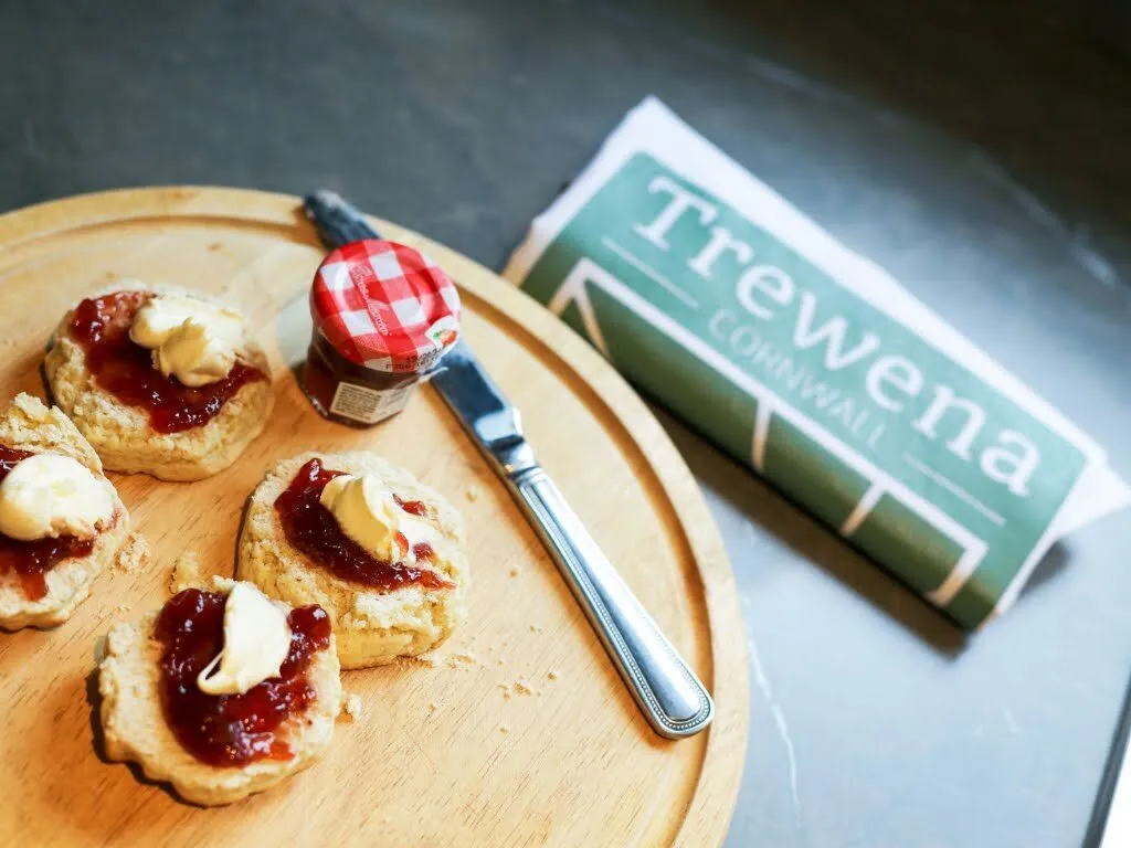
What is meant by Jam First?
"Jam first" is the Cornish way to serve a cream tea. The split scone gets a layer of jam (traditionally Cornish strawberry) spread on first, then a dollop of clotted cream on top. The Devon convention reverses the order, with cream first and jam on top. Both counties claim their version is correct, and the argument has run for centuries. In Cornwall, "jam first" is taken seriously enough that you will see it on cafe menus, scribbled on chalkboards in tea rooms, and worn on T-shirts in the more partisan corners of the county.
The cream itself is Cornish clotted cream, a thick, slightly yellow cream made by gently heating unpasteurised whole milk and skimming off the crust that forms on top. It has held PDO (Protected Designation of Origin) status since 1998, meaning only cream made in Cornwall to the traditional method can carry the name.
K
What does Kernow mean?
Kernow is the Cornish-language word for Cornwall. Cornish (Kernewek) is one of the six recognised Celtic languages, closely related to Welsh and Breton. The language nearly died out in the 18th century but has been revived through schools, signage, music and cultural campaigns since the early 20th century. You'll see Kernow on road signs, pub names, businesses, the Cornish flag (Saint Piran's flag, a white cross on black) and in the names of campaigns like Kernow Bys Vyken (Cornwall Forever).
L
Where is the Lizard Peninsula?
The Lizard Peninsula is the southernmost peninsula of mainland Britain, between Falmouth Bay and Mount's Bay on the south coast of Cornwall. Lizard Point, at its tip, is the southernmost point of mainland Britain. The peninsula is largely an AONB / National Landscape and includes Kynance Cove, Lizard Lighthouse, Coverack, Cadgwith and the Lizard village itself. Most of the peninsula is unique geologically, sitting on serpentine rock that gives the headlands their distinctive red, green and black colouring.
For a day-trip itinerary, see our Lizard Peninsula one-day road trip guide.
M
What is Moorstone granite?
Moorstone is the high-quality granite traditionally quarried in Cornwall's Mabe Parish (and similar Cornish quarries) from the medieval period through to the 20th century. It was prized for its workability, its durability and its even grain. Cornish Moorstone was used in the Duke of Wellington's monument in London, the kerbstones of London's streets, dozens of church fonts, harbour walls across the south west, and the foundations of major engineering projects. Many of the original quarries are now flooded and home to wild swimming or aquapark sites.
N
What is a National Trail (in the UK)?
A National Trail is a long-distance walking route designated and maintained by the UK government. Cornwall holds the longest section of the South West Coast Path, a 630-mile National Trail running from Minehead in Somerset to Poole in Dorset. National Trails are way-marked with the small acorn symbol at every junction, surface-maintained by the trail association, and free to walk year-round.
P
Where is Penwith?
Penwith is the far-western peninsula of Cornwall, the bit of land that sticks west from St Ives on the north coast and Penzance on the south to Land's End at the tip. It is one of the most ancient cultural landscapes in Britain, dotted with Neolithic stone circles, Iron Age hill forts and medieval mining sites. The cliffs around Sennen Cove, Cape Cornwall and Pendeen are some of Cornwall's most dramatic walking. The area was an early adopter of the National Landscape designation.
For more, see our Penwith ancient walks guide.
R
What is a rip current?
A rip current is a narrow, fast-moving channel of water that pulls away from the shore through breaking waves. Rips form where water funnelled onto a beach by waves finds the easiest route back out to sea, often near headlands, piers, groynes or rock outcrops. They are the cause of the majority of UK lifeguard rescues every year. The defensive response is Float to Live: don't fight the current, float on your back, then swim parallel to the beach to escape the rip's pull before swimming back to shore.
For more, see understanding seaside safety in Cornwall.
Where is the Roseland Peninsula?
The Roseland Peninsula is the small wooded peninsula on the north-east side of the Carrick Roads, opposite Falmouth. It includes St Mawes, Portscatho, Veryan and the south-coast cliffs around Nare Head. It's one of Cornwall's most consistently atmospheric regions: gentle walking, tidal-creek villages, the King Harry Ferry across the Fal, and a slower pace than the more visited peninsulas. Reachable by ferry from Falmouth.
S
What is the South West Coast Path?
The South West Coast Path (SWCP) is a 630-mile National Trail running from Minehead in Somerset, around the Cornish coast via Land's End and the Lizard, to Poole in Dorset. It's the longest National Trail in England. Cornwall holds around 300 miles of the path. Way-marked throughout with the acorn symbol, the SWCP is free to walk year-round, and most of it is open to dogs on leads. The book and 2025 film of The Salt Path by Raynor Winn, which charts a thru-walk of most of the trail, brought a new audience to the route.
For more, see our best South West Coast Path walks in Cornwall guide and our Salt Path in Cornwall walking guide.
What are Stannary towns?
Stannary towns were the medieval Cornish towns granted special administrative rights over the tin mining trade by royal charter. The five Stannary towns in Cornwall were Helston, Truro, Lostwithiel, Liskeard and (later) Penzance. Each had a stannary court that adjudicated disputes between miners and merchants. The Stannary Convocation was a kind of Cornish parliament for the mining industry that operated from the 13th to the 17th centuries. The legacy survives today in the names of pubs, streets and civic buildings across Cornwall.
T
What is the Tin Coast?
The Tin Coast is a UNESCO World Heritage Site running along Cornwall's far-western north coast from St Ives Bay around Pendeen to Cape Cornwall and the cliffs above Sennen. It's the most concentrated cluster of preserved Cornish mining heritage in the county: ruined engine houses, mining trails, restored chimney stacks, and the Geevor Tin Mine museum at Pendeen. The whole stretch is also some of the SWCP's most spectacular walking. Inscribed on the World Heritage list in 2006 as part of the Cornwall and West Devon Mining Landscape.
V
What is via ferrata?
Via ferrata (Italian for "iron way") is a permanent system of steel cables, rungs and ladders fixed to a rock face, allowing non-technical climbers to ascend terrain that would otherwise need full climbing experience. Climbers wear a harness and lanyards that clip to the cable so they cannot fall. Cornwall's only via ferrata is at a former 60-acre granite quarry near Mabe Burnthouse, with high-wire bridges, climbing pitches and a clifftop zipline finish.
For more, see our Via Ferrata Cornwall visitor guide.
W
What is wild swimming?
Wild swimming (also called open-water swimming or outdoor swimming) is swimming in natural water (sea, river, lake, tidal pool or quarry) rather than a chlorinated pool. It's grown into a major UK leisure activity over the last decade, with year-round swim groups at most coastal towns. Cornwall's combination of sheltered coves, tidal pools, river mouths and woodland waterfall pools makes it one of the country's best wild swimming regions. Cold water shock is the main risk, especially outside summer.
For more, see our best wild swimming spots in Cornwall guide.
More from the local guide
For the practical side of these terms (actual beaches, walks, swims and itineraries), see our cluster of Cornwall guides:
Tags
Stay in touch
Occasional Cornwall updates from Rich at Trewena. Around four times a year, never more.
Planning a trip to Cornwall?
Three one-bedroom cottages on a smallholding on the edge of Falmouth. A genuine Cornish base for couples and singles.