A Falmouth Walking Tour: A 4-Mile Itinerary Through Castle, Beaches and 350 Years of Town History
Falmouth is a town with three hundred and fifty years of history written into a one-mile radius. The Killigrew family founded it in 1660. Henry VIII fortified the headland a century before that. A Victorian railway turned it into a seaside resort in the 1860s. A modern maritime museum and a contemporary cocktail bar bookend the walk. The full town itinerary is a four-mile loop that takes in all of it: harbour, headland, castle, beaches, Victorian gardens, the historic High Street, and the kind of urban texture that makes Falmouth feel older than it looks. Walkable in around an hour and a half flat; better as a half-day or full afternoon with the proper stops built in. No car required.
This is the walk we send our guests on for their first afternoon at the cottages.
The route in brief
- Start: National Maritime Museum at Events Square (south end of central Falmouth)
- End: Chintz Bar & Underland Music Venue in central Falmouth, or carry on to The Moor (Falmouth's central square) for a true town finish
- Distance: 4.2 miles by Google Maps walking
- Time: 1 hour 34 minutes flat; half a day with the stops in
- Direction: anti-clockwise (Pendennis first, beaches and gardens second half, town finish)
- Highlights along the way: Pendennis Castle, the view of St Anthony's lighthouse, Castle Beach, Gylly Beach, Gyllyngdune Gardens, the Pavilion, the High Street, the Killigrew Monument, Jacob's Ladder, the Church of King Charles the Martyr
- Dog-friendly, family-friendly, year-round
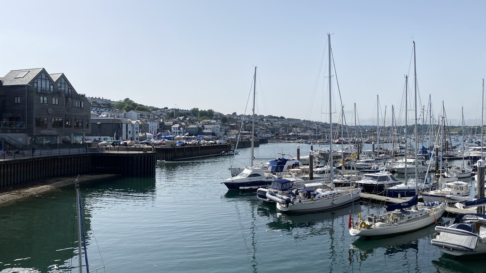
Start: Events Square and the modern harbour-front
Begin at Events Square, the modern paved quayside opposite the National Maritime Museum Cornwall at the south end of the town. The Maritime Museum opened in 2003 and is the most striking modern building on the harbour, worth a full visit on a separate day (see our Maritime Museum guide).
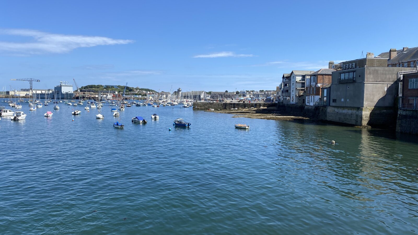
Look out across the harbour and you are looking at the reason Falmouth exists. The Carrick Roads (the wide estuary in front of you) is the third-deepest natural harbour in the world, sheltered from every Atlantic gale. The Romans used it. Medieval pilots used it. By the late 17th century the Royal Navy was using it as a base, and by the 1680s Falmouth had become the embarkation port for the Royal Mail Packet Service, the network of small fast ships that carried mail (and people, and gold, and intelligence) to North America, the West Indies, Iberia and the Mediterranean for two hundred years.
The square itself is the staging ground for Falmouth's outdoor events: Falmouth Week's regatta in August, the Sea Shanty Festival in June, the Oyster Festival in October (see our Falmouth events guide for the full year).
Out along Castle Drive towards Pendennis Point
From Events Square head east along Castle Drive, the road that wraps around the headland and traces the edge of Falmouth Docks, the working ship-repair yard and deepwater port. The docks opened in 1860 and have been Falmouth's industrial backbone ever since. Cargo ships, occasional cruise liners, a tugboat or two, cranes and gantries: the working harbour at its most visible.
Castle Drive climbs gently. About a mile from the start, the road curves left and opens onto the headland proper.
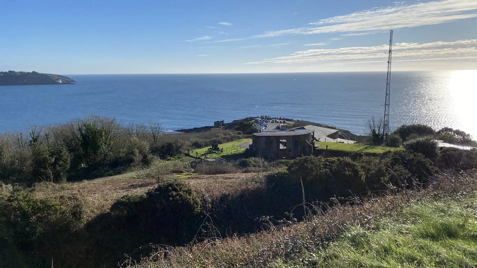
Pendennis Point and Pendennis Castle
The first big landmark of the walk. Pendennis Castle is one of Henry VIII's coastal artillery forts, built in the 1540s as part of the defensive line against the French and Spanish, paired across the harbour mouth with St Mawes Castle (see our St Mawes day trip guide for the sister fort). The castle is the visible landmark on the headland: a circular Tudor keep inside a star-shaped Elizabethan outer wall, with later additions through the centuries.
Pendennis was one of the last royalist strongholds in the English Civil War, holding out for five months under siege in 1646 before surrendering. The castle stayed in military use through to the Second World War, with the Half-Moon Battery (the WWII gun emplacement visible at the headland) added in 1903. The site is now run by English Heritage; see our Pendennis Castle guide for the full visit.
For the walking tour, the route loops around the outside of the castle to the very tip of Pendennis Point. Stop here for tea or an ice cream at the cafe by the car park. Sit on the grass and take in the view: across Falmouth Bay to the west, the open Channel to the south, and the broad arc of the bay reaching towards the white lighthouse on St Anthony's Head opposite.
That lighthouse, by the way, is St Anthony's Head Lighthouse, built by Trinity House in 1835. It featured as the lighthouse in Doc and Sprocket's framing scenes in the British version of Fraggle Rock, the Jim Henson series from the 1980s. A small but durable piece of Falmouth Bay trivia.
Back along Cliff Road and over Castle Beach
From Pendennis Point the route follows the cliff path back westwards along Cliff Road, with Castle Beach below. Castle Beach is the smaller cove east of Gyllyngvase, quieter than Gylly, with some of the best rockpools in the town at low tide. See our Castle Beach guide for the dedicated beach.
If you are walking on a warm day, the steps down to Castle Beach make a good detour for a paddle or a coffee at the cafe at the back of the beach. Otherwise, the cliff path looks down at the cove and continues on.
The cliff path runs above the rocks for about half a mile, with views back to Pendennis on one side and Falmouth Bay opening out on the other.
Gyllyngvase Beach
The cliff path joins the seafront at the eastern end of Gyllyngvase Beach (or simply Gylly), Falmouth's main town beach: a wide curve of clean sand, a seafront promenade, and the back-of-the-beach cafes. Beach House sits at the back of the beach for proper lunches; Gylly Cafe at the eastern end is the cheaper alternative. See our Gyllyngvase Beach guide for the dedicated beach.
The natural pause: another coffee, an ice cream, a paddle if the weather is right. Sit on the seawall for ten minutes. Halfway through the walk; the second half is uphill and inland.
Up to Princess Pavilion and Gyllyngdune Gardens
From the western end of Gyllyngvase Beach the route climbs gently up Melvill Road to the Princess Pavilion and the Victorian gardens at Gyllyngdune, the cultural counterpoint to the harbour-front start of the walk.
The Pavilion and gardens date from the late 19th and early 20th centuries, the era when Falmouth was reinventing itself from a working port into a Victorian seaside resort. The arrival of the Cornwall Railway in 1863 (the Brunel-engineered line to Truro that finally connected Cornwall to the rest of Britain by rail) brought the first wave of seaside tourists, the seafront hotels were built, and the Pavilion and gardens went up as part of the cultural infrastructure of the new resort. See our Princess Pavilion guide for the venue.
The wrought-iron bandstand sits on the lawn at the front of the gardens; the conservatory wing of the Pavilion extends to the side. Free to enter, beautiful in any season, with views across Falmouth Bay from the seafront-side end of the gardens. The Pavilion Cafe is open through the day for coffee and cake.
Back into town: the upper town and the High Street
From the Pavilion, head north into the upper town along Killigrew Street, the long uphill spine that runs from the seafront end to The Moor, Falmouth's central square. Granite Victorian villas, walled gardens, the residential rhythm of the upper town, where Falmouth's permanent population lives.
As you reach the central town, the route drops down the High Street towards the harbour-front, passing most of Falmouth's pre-Victorian fabric in a single ten-minute walk. Three things to look out for on the way:
The Killigrew Monument
The granite obelisk standing on The Moor was raised in 1737 by Martin Lister Killigrew in memory of the Killigrew family, who founded Falmouth. Before the Killigrews, the area was open shoreline and a few fishermen's cottages around the natural harbour. In 1660, Sir Peter Killigrew secured a royal charter from King Charles II to develop a town around the family's Arwenack House and the harbour. Within fifty years, Falmouth had grown into one of Britain's busiest ports. The town's existence is the Killigrews' legacy; the monument is the family's marker.
The Church of King Charles the Martyr
A short walk off the High Street on Church Street stands the Church of King Charles the Martyr, Falmouth's parish church. Built in 1665 and dedicated to King Charles I, who was executed by Parliament in 1649 and considered a martyr by royalists. One of only a handful of churches in England dedicated to Charles I, reflecting Falmouth's royalist sympathies (and the legacy of Pendennis Castle's last-stand siege twenty years earlier). The church itself is plain on the outside; the interior is full of Falmouth's maritime history in monuments and stained glass.
Jacob's Ladder
Further along the High Street, on the right, look up. Jacob's Ladder is 111 stone steps climbing the hillside from the High Street to the upper town. Built in 1839 by a local builder named Jacob Hamblen (not the biblical Jacob) as a shortcut between his properties on the two levels. The route does not climb the Ladder, but it is one of Falmouth's most recognisable landmarks, and worth a sit on the bottom step for a photograph.
The High Street itself is the main artery of the historic town: independent shops, pasty shops (Rowes, Warrens), the Pannier Market, an excellent independent bookshop, the Cornish Bank music venue on the way, and the kind of high street where almost every shopfront is one-of-one rather than a chain.
End: Chintz, or carry on to The Moor
The natural end-point is Chintz Bar and Underland Music Venue, a cocktail bar and small music venue in central Falmouth and one of the cool places to end an afternoon's walk with a drink. Alternatively, carry on into The Moor itself, Falmouth's central square.
The Moor is built on what was once a tidal marsh on the edge of the town (hence the name), drained and developed through the 18th century as Falmouth grew. The granite obelisk of the Killigrew Monument stands at its centre. From The Moor it is a five-minute walk back down to Events Square if you want to close the loop properly.
What to stop for along the way
The walking tour can be done flat in around an hour and a half. The half-day version with stops works much better:
- A cup of tea or ice cream at Pendennis Point with the headland view
- A coffee at Castle Beach with the rockpools below
- Another coffee or ice cream at Gylly, or proper lunch at Beach House
- Cake at the Pavilion Cafe in Gyllyngdune Gardens
- A pasty on the High Street as you walk back through the historic town
- A drink at Chintz at the end
The pace is yours. The walk works at three hours or six.
Practical notes
- Best time of year: any. Summer for swimming; autumn for clarity of light at the headland; winter for storm-watching at Pendennis; spring for the gardens at the Pavilion
- Older walkers: no extreme climbs; gradients on Castle Drive and Killigrew Street are gentle. Plenty of rest stops built in.
- Wheelchair-friendly: most of the route. Castle Drive, Cliff Road, the Pavilion gardens and the High Street are all paved or made-up surfaces. The steps down to Castle Beach are the only place that needs to be bypassed.
- Dogs: welcome throughout. Off-lead in places on Pendennis Point and in the gardens
- Kids: works well for school-age (six upwards). The history bits land for older kids; the headland and beaches carry the younger ones
- Weather: a coat and proper shoes in winter; sun cream in summer
More Falmouth walks and town guides
- Pendennis Castle: the Henry VIII fort at the headland
- Gyllyngvase Beach: the headline town beach mid-route
- Castle Beach: the smaller rockpool beach you pass on the cliff path
- The Princess Pavilion, Falmouth: the Victorian concert venue and gardens
- The Cornish Bank, Falmouth: the music venue on the High Street
- National Maritime Museum Cornwall: the museum at Events Square
- Best restaurants in Falmouth and Penryn: for lunch on the route
- Walks near Falmouth and Penryn: the longer walks out of town
- Gylly, Swanpool and Maenporth walk: the longer coast walk that extends from Gylly westwards
- A long weekend in Cornwall for couples: the long-weekend itinerary the walking tour slots into
- A day trip to St Mawes from Falmouth: the one ferry day to pair with the town walk
Tags
Stay in touch
Occasional Cornwall updates from Rich at Trewena. Around four times a year, never more.
Planning a trip to Cornwall?
Three one-bedroom cottages on a smallholding on the edge of Falmouth. A genuine Cornish base for couples and singles.